SAS Planet is a fantastic tool for exploring high-resolution satellite imagery and maps. But have you ever felt the map doesn't quite match your needs
SAS Planet is a fantastic tool for exploring high-resolution satellite imagery and maps. But have you ever felt the map doesn't quite match your needs? Well, fear not! The secret lies in understanding map projections. Don't worry, it's simpler than it sounds! This article will guide you through the process of changing map projections in SAS Planet, unlocking a whole new world of possibilities.
What are Map Projections?
Imagine trying to flatten a perfectly round orange peel. It's impossible without creating distortions. Likewise, projecting the spherical Earth onto a flat map necessitates compromises. Different projections prioritize different aspects, such as area accuracy, shape preservation, or distance measurement.
Why Change Projections?
Depending on your purpose, a specific projection might be more helpful. For example:
Mercator: Maintains accurate shapes, ideal for navigation and measuring distances. However, it exaggerates landmasses at higher latitudes.
Equidistant Aicoff: Represents areas more accurately, perfect for global comparisons.
Robinson: A good balance between shape and area, often used for general reference maps.
Changing Projections in SAS Planet:
Open SAS Planet.
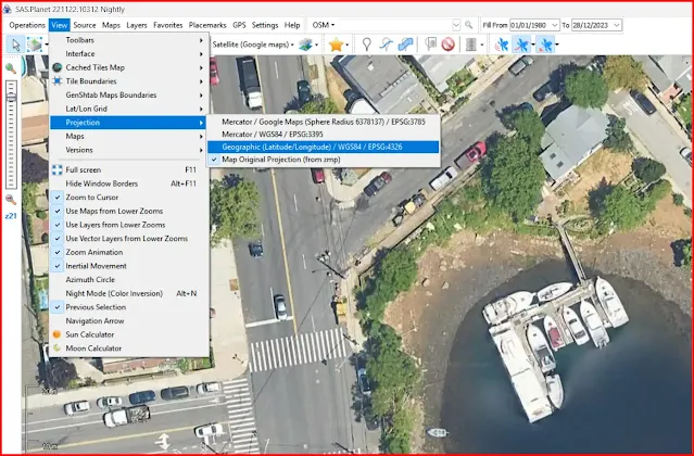
Navigate to view in the menus toolbar.
Under "View," find the "Projection" dropdown menu.
Explore the available options and consider your needs. For example, "Mercator" for navigation, "Equidistant Aicoff" for global comparisons, or "Geographic (Latitude/Longitude) WGS84" for a general overview.
Select your preferred projection.
Click "Apply" and voila! The map instantly transforms to reflect your chosen projection.
Tips and Tricks:
Experiment with different projections to see which best suits your needs.
Remember, no single projection is perfect. Choose the one that minimizes distortion for your specific task.
Many online resources explain the pros and cons of different projections.
Beyond the Basics:
SAS Planet also allows saving custom projections and even defining your own. However, this requires deeper GIS knowledge. For most users, the built-in options provide ample flexibility.
Explore the World:
Now that you know how to change map projections, dive into SAS Planet and rediscover the world. From navigating unfamiliar terrain to comparing global trends, map projections unlock a new dimension of exploration. So go forth, change your perspective, and let SAS Planet guide your journey!


