One of the best ways to explore the capabilities of Navionics without an upfront investment is through its free trial. This allows potential users
Navionics is renowned for offering top-tier marine charts and navigation tools for boaters, sailors, anglers, and marine enthusiasts. One of the best ways to explore the capabilities of Navionics without an upfront investment is through its free trial. This allows potential users to experience the app’s full suite of features before committing to a subscription. In this guide, we'll explain everything you need to know about the Navionics free trial, from how to sign up to maximizing the experience.
By combining Navionics with SASPlanet, you can significantly enhance your marine mapping experience, making sure every journey is as safe and efficient as possible. you can download SAS Planet 2024 with Navionics Maps.
What Does the Navionics Free Trial Offer?
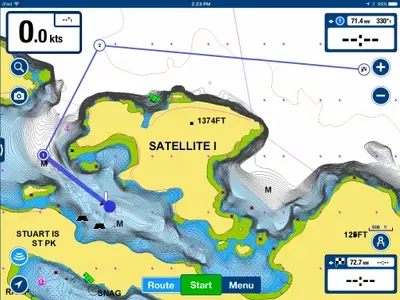
The Navionics free trial provides full access to its comprehensive marine charts and advanced features for a limited time. During this trial, users can explore various regions, plan routes, and benefit from many advanced tools.
Key Features Available in the Free Trial:
- Nautical and Sonar Charts: Access both coastal and inland water charts.
- Community Edits: View real-time updates contributed by fellow boaters.
- Route Planning: Plan your next boating or fishing trip by setting waypoints and routes.
- Weather and Tides Info: Overlay weather conditions, wind forecasts, and tide data.
- Cross-Device Syncing: Sync your data across multiple devices, ensuring your plans are accessible whether you're on your phone, tablet, or PC.
How to Sign Up for the Navionics Free Trial
Getting started with Navionics' free trial is simple. Here's a step-by-step guide:
- Download the App: Head to the App Store (for iOS devices) or Google Play Store (for Android devices) and download the Navionics Boating app.
- Create an Account: Upon opening the app, you'll be prompted to create a Navionics account. This account is essential for accessing and syncing your charts across devices.
- Choose Your Region: Select the chart region you want to explore during the free trial. Navionics covers both coastal and inland waters worldwide, so pick the one most relevant to your needs.
- Activate the Free Trial: Once your region is selected, the free trial will automatically activate, giving you full access to all the app’s features for the trial period.
Maximizing Your Navionics Free Trial
To get the most out of the Navionics free trial, here are some tips and tricks to ensure you explore all the features it offers:
- Explore Multiple Regions: While your free trial only allows access to one region at a time, make sure you explore the areas that are most important for your boating adventures. You can download charts for your region and test their accuracy and detail before purchasing.
- Test Route Planning: Utilize the route planning tool to plot potential boating trips. By setting waypoints, you can estimate distances, times, and even fuel consumption (if applicable).
- Use Weather Overlays: One of Navionics' strengths is its integration of weather data. Make sure to test out the weather overlays for wind, tide, and currents to see how it impacts your trip planning.
- Try SonarChart™: If you’re an angler, you’ll want to try out the SonarChart feature, which provides real-time depth readings from sonar devices to help you find the best fishing spots.
- Check Community Edits: The community edits feature is great for staying informed about real-time conditions like obstructions, new marina facilities, or navigation aids. Explore this feature and see how it could improve your future boating trips.
What Happens When the Free Trial Ends?
Once your Navionics free trial period ends, you'll lose access to the premium features, but your account will still remain active. You’ll then be given the option to subscribe to Navionics to continue using the charts and tools. The app offers different subscription plans depending on the coverage area and the duration you require. There’s also a one-time purchase option for those who prefer not to deal with recurring payments.
Why Subscribe to Navionics After the Trial?
While the free trial gives you a good overview of what Navionics has to offer, subscribing unlocks long-term access to several valuable features:
- Unlimited Chart Updates: Stay updated with the latest chart revisions and user edits.
- Wide Coverage Areas: Expand your access to multiple regions instead of one limited area.
- Advanced Tools for Anglers: Features like Fish Mapping (if available in your region) make Navionics especially useful for fishing enthusiasts.
- Cross-Device Access: Sync your routes and maps across multiple devices, ensuring seamless navigation whether you're using a tablet, smartphone, or GPS device.
Enhance Your Navionics Experience with SAS Planet
For users who enjoy pairing their navigation tools with additional mapping software, SAS Planet can complement Navionics' capabilities. SAS Planet allows you to download satellite imagery and overlay it on your marine charts for even more detail. This way, you can better visualize coastlines, ports, and other important navigational elements when planning your routes.
The Navionics free trial is an excellent way to experience premium marine navigation without an upfront commitment. It allows you to explore charts, plan routes, and utilize community edits, giving you a feel for how Navionics can improve your time on the water. If you’re serious about marine navigation, subscribing to Navionics post-trial ensures you maintain access to vital tools, up-to-date charts, and comprehensive weather data.


